LiDAR
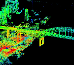
LiDAR—Light Detection and Ranging—is a remote sensing method used to examine the surface of the Earth. This technology is being used for a wide variety of applications including high-resolution topographic mapping, 3D surface modeling as well as infrastructure and biomass studies. LiDAR data is very accurate, high resolution 3D data captured using special sensors. Mainly LiDAR—can be classified as 4 types based on their mapping style
|
Our Services |
Contact Us
99, 1st Floor, MB Road (Next to Basist Complex) ,Khanpur, New Delhi 110062
|
Services
GIS Application Development
|
AchievementMMC ISO 9001:2008 NewsletterA moment of immense proud and prestige arouse after levels of churning and grinding. |
Follow Us
We are all time available in our Social Media Networks for supporting our customers. Feel free to post your feedbacks on our links below. We will happy to see your feedbacks and will be in touch regularly.
|
Copyright © 2011 - All Rights Reserved - Multimind Creations