3D City Modelling
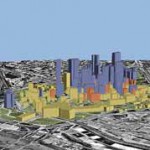
3D City Modeling integrates geo-referenced imagery with GIS data into a virtual environment. By providing an accurate, photo-realistic 3D model of any location, City Models are a very powerful tool for city planning, tourism, real estate, and security. It is a highly efficient and productive tool for spatial planning projects. It provides planners with futuristic, visually comprehensible scenario. The 3D city models are created on the basis of existing orthophotos and height models and can be used for 3D visualization of a new structure or infrastructure projects. |
Our Services |
Contact Us
99, 1st Floor, MB Road (Next to Basist Complex) ,Khanpur, New Delhi 110062
|
Services
GIS Application Development
|
AchievementMMC ISO 9001:2008 NewsletterA moment of immense proud and prestige arouse after levels of churning and grinding. |
Follow Us
We are all time available in our Social Media Networks for supporting our customers. Feel free to post your feedbacks on our links below. We will happy to see your feedbacks and will be in touch regularly.
|
Copyright © 2011 - All Rights Reserved - Multimind Creations